The OceanCurrent team has been combining satellite altimeter measurements of ocean sea level with tide gauge data to produce our Gridded Sea Level Anomaly (GSLA) product for longer than IMOS has existed. Indeed, the inclusion of tide gauges has long been a distinguishing feature of our product. It enables us to estimate the alongshore, geostrophic component of the surface current velocity anomaly over the continental shelf as well as in the deep ocean where the altimeter data suffices.
In March 2026 we finished a new version (DM03 - the 3rd version of our Delayed Mode re-analysis) of GSLA (link to journal article coming) [DM03 data files]. Here, we explore the question of how accurate the DM03 geostrophic estimates of surface currents are, over the continental shelf and slope, using the whole archive of IMOS Australian National Mooring Network (ANMN) current meters (comprising 1492 instrument deployments as of Dec 2025).
| National maps of skill, for three 6-year periods | |
|---|---|
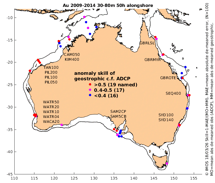 |
These three maps (click the one at left to see the others) give a nation-wide overview assessment of the relative accuracy of our satellite and tide gauge-based estimates of alongshore velocity at all the locations of the (evolving) ANMN shelf array of Acoustic Doppler Current Profilers (ADCPs). We define skill as 1-MAE/(MM+MO), where MAE is the Mean Absolute Error, defined as the mean over 6 years of the absolute value of the (de-meaned) daily error; the error is the difference of the two velocity estimates, resolved along the principal axis of the ADCP data. MM is the Mean (absolute, de-meaned) 'Model' (the model being the geostrophic velocity interpolated to the location of the ADCP). MO is the mean (absolute, de-meaned) Observation (the observation being the ADCP data, averaged between 30m and 80m and over a 50h period). FAQs: 1) why de-mean everything? A: because errors of the time-mean velocity are not determined by the altimeter or tide gauge observations (instead, it involves the mean dynamic topography and how gauges are levelled with the altimeter observations). 2i) why only use the ADCP data deeper than 30m? A: because ADCP data near the surface has more error and non-geostrophic velocity signals (surface reflections, Ekman spiral, etc), 2ii)...and why only shallower than 80m? A: because the altimetry and tide gauges measure the pressure gradient at the surface, so the geostrophic velocity derived from that is also at the surface, not at depth, 3) why average the ADCP data over 50h? A: to remove tidal and inertial oscillations (which are certainly not geostrophic), and to be consistent with our filtering (see paper - ref) of tide gauge data, 4) why look only at the alongshore velocity component? A: because we know i) we cannot estimate the details of the along-shelf pressure gradient, and ii) it is not in geostrophic balance with the across-shelf velocity, anyway. Results: For 2009-14, 2015-20 and 2021-25, the measured skill exceeds 0.5 at 37% (19/52), 43% (16/37) and 41% (12/29) of locations (shown in red, with station codes listed). The following sections go into more detail. |
| Regional maps showing velocity ellipses and vector skill | |
|---|---|
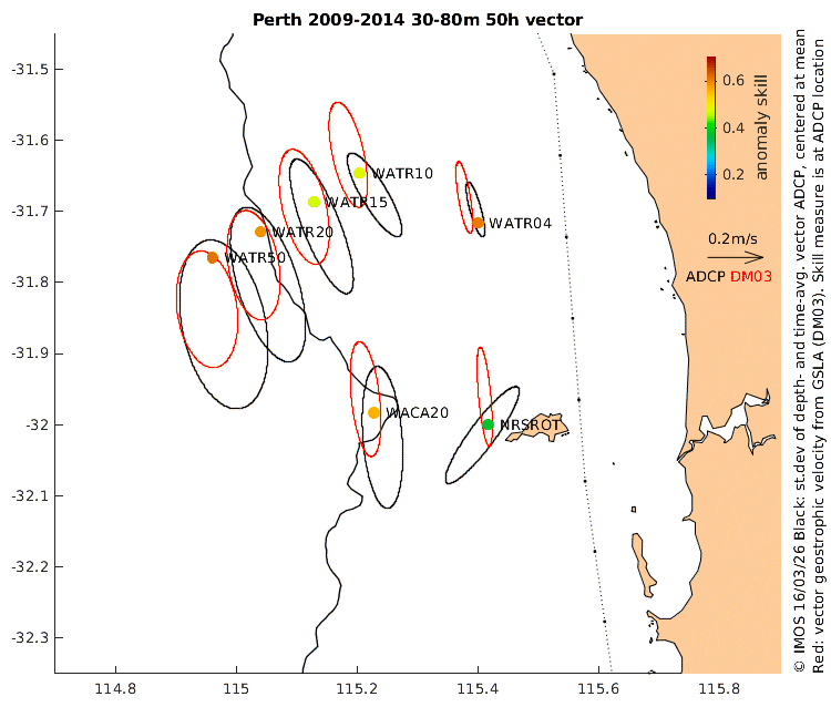 |
The ANMN moorings are mostly deployed in groups, which these maps zoom in on. Mooring locations are shown as dots whose colour indicates the vector skill (defined as above but here for the vector velocities). Ellipses characterise the strength, direction and eccentricity of ADCP and geostrophic velocities. The offset of each ellipse centre from the skill dots denotes the respective estimate of the mean velocity. Notes: 1) For the ADCPs, the available data is unlikely to span the whole 6-year time interval of the analysis, in which case removing the mean will remove some of the inter-annual variability, 2) While the mean geostrophic velocities are mostly determined by the gradients of the Mean Dynamic Topography (see above), there are also changes from one 6-year period to the next of the time-mean sea level height anomaly gradients. Results: In the example at left (click the image to see other regions) we see analyses for the Perth region where there were 7 ADCP moorings maintained in the early phase of IMOS (2009-14). At all but one location, the DM03 principal axis of velocity variability and the eccentricity (the ratio of major to minor axis) estimates agree quite well with the ADCP observations, which says that the geostrophic velocities (even the across-shelf component) are of the right size (neither too weak nor too strong). The next section looks at the errors on a daily basis. Footnotes: 1) The reason for the Rottnest Island result is that real ocean currents are steered by topography, of which the DMO3 analysis is ignorant (see how the dotted line of interpolated sea levels provided to DM03 bypasses east of Rottnest Island in a straight line). The ADCPs at NRSKAI, GBRHIS, GBRHIN are similarly affected. 2) It is unclear why the skill at WATR15 and WATR10 is low, when the skill at the other locations is quite high. 3) The skill is low, and the geostrophic along-shore component of velocity too weak at SAM1DS, SAM4CY, SAM7DS and SAM3MS. We suspect this is because Kangaroo Island is a major obstacle to the along-shore flow. One way to direct the alongshore geostrophic flow to go south of KI would be to reroute the line of interpolated coastal sea level offshore of KI rather than inshore of it. But really, this region is too complex topographically for our simple method to be appropriate. |
| Time series of alongshore velocity, ten stations and 1 yr/page. | |
|---|---|
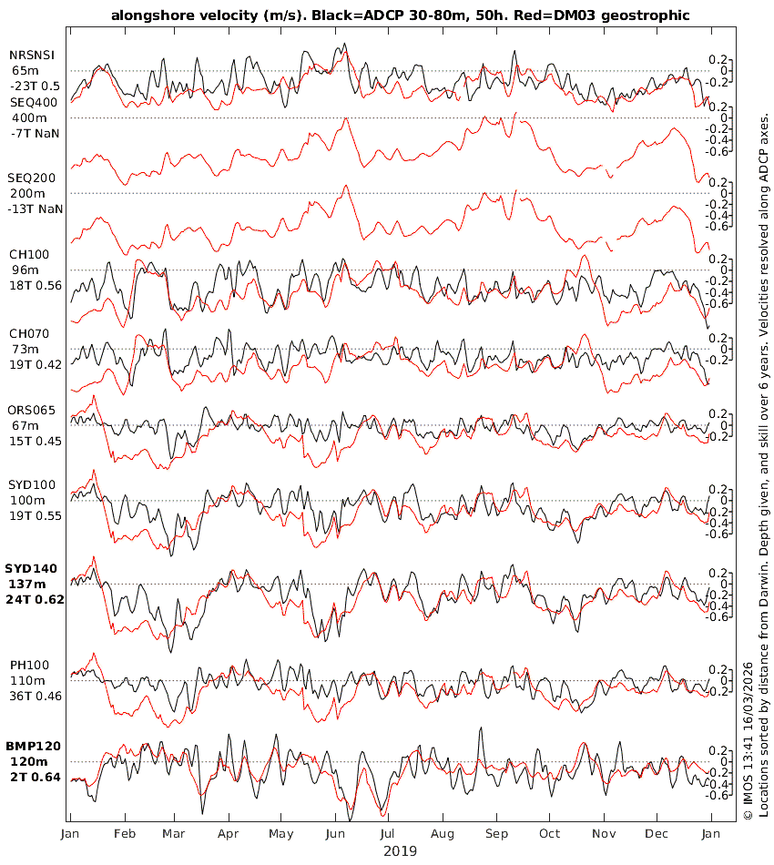 |
These plots of the DM03 estimates and ADCP observations of the alongshore component of near-surface, sub-tidal velocity (neither de-meaned) step through the years from 2009 to 2025, and through all the ADCPs, sorted by distance from Darwin. Station codes (see previous section for locations), water depth, alongshore-axis direction and skill (evaluated over 6 years, not just the year shown) are listed. Results: In the example at left (click it to see other years and groups of locations) we see two cases where the skill is relatively high (0.65, see names in bold, locations: SYD140 and BMP120). Inspection of the time series is consistent with the quantitative estimate of skill: the correspondence of the DM03 and ADCP velocities is clearly good. What the skill measure does not convey is that good agreement is seen for both the weather-band (periods of several days) and eddy-band (periods of a month or two) velocity variations of up to 1m/s (see June 2019 at BMP120 and the 4 periods of strong southward flow at SYD140). Even higher skill (0.68 and 0.75) is seen at SAM2CP and SAM5CB (locations) where it is weather-band variability, with a bit of annual cycle that drive the high skill. Of all the ANMN ADCP locations, SEQ400 is one where the strongest currents have been measured. The unequal (ADCP and DM03) ellipse sizes says that the geostrophic estimates underestimate the ADCP observations. But measuring strong currents in deep water poses a technical challenge. The mooring line gets pushed over, so near-surface (0-100m) flow speeds exceeding about 1m/s go unmeasured, implying that the underestimation is, itself, underestimated. (See plot of depth and velocity vs time). The time series plots show that the geostrophic estimate of the southward surface current also never exceeded 1m/s in either 2012 or 2013 when the instruments were in place. This can only be a coincidence, because the two techniques are completely independent. Another interesting point is that the salient observation of a northward flow event (on 29 Oct 2012) was only estimated as a weakened southward flow at the location of the ADCP. Indeed, over the 2 years, only one (on 3 July 2012) of 5 northward flow events was correctly estimated in terms of magnitude as well as timing. Despite these imperfect results focussed on extreme events, the overall skill (0.61) was fairly high, and visually, the characteristic time-scale of variability is about right. It should also be noted that a map view of the 29 Oct 2012 event (showing northward flow in shallower water) leaves a different impression to the time series view, because our eyes are more tolerant of errors of exact placement. We end this short discussion of results with an example of a location where high skill (0.7) is driven primarily by annual-timescale variation of current strength: GBRMYR (location, time series), and hope that readers find other stations of interest to them in the archive of plots. |
Our geostrophic estimates of currents over the continental shelf are certainly far from perfect, but do have usable skill at many places, and very high skill at a few places. Indeed, it may surprise some readers that there is any skill at all, considering that the geostrophic estimate is based on only two sources of sea level information, and very simple physics. This is in contrast to hydrodynamic models, which use many inputs and very complex physics. The geostrophic estimates of currents establish a benchmark for hydrodynamic models to beat.
Unfortunately, there is no simple rule for where our estimates are useful, other than 1) not on the wide Bonaparte Gulf or Kimberley shelves, and 2) not too close to islands, complex topography, or openings to enclosed waters.
The beauty of the archive of geostrophic currents is that it extends from 1993 to the present, making it potentially useful for applications requiring, for example, 1) an estimate of what the currents were at some time when there were no in situ observations (or validated model) available, or 2) estimates of various long-term statistics, e.g. how often is the flow speed at location X less than 0.2m/s for more than 2 days?
When our technical paper is published we will include the citation here.